Open Access
 Abstract
Typhoon surge is the phenomenon of seawater level rises higher than the normal levels (tidal water level) under the combined effect of many factors during typhoons. Along the Vietnam coast, this phenomenon occurred quite often and very dangerous, especially when occurring at the same time with high tide. There are many research projects and publications relative to this problem, such as National projects. This phenomenon caused by strong wind and air pressure depression during typhoon acting therefore often happened before or just during the typhoon landfall. However, statistically, depending on the track and movement speed of the typhoon, the surges sometimes occur several hours after the typhoon landfall time. In this research, the integrated model for surge, wave, and tide during typhoon acting (SuWAT) is applied to simulate sea-level oscillation due to typhoons by two ways: (1) - the wind and air pressure fields are described the analytical model with the typhoon parameters (track, air pressure depression at the typhoon center, max wind speed …) re-analyzed from the observed data and (2) - from the numerical model WRF for weather prediction. With the same calculating domain, grid, open boundary conditions, the calculated results of SuWAT show that the sea level oscillation obtained by using wind and air pressure fields from WRF is better than that by using the analytical model in comparison with the observed data. The main reason for the difference in the calculation of the rising water level is that the WRF has well simulated the post-typhoon circulation combined with the monsoon at the time after the typhoon landfall time. The results of the study will be valuable experiences in alerting and selecting typhoon surge projections for the Northern coastal strip.
INTRODUCTION
Typhoon surge is the phenomenon of seawater level rises higher than the normal levels (tidal water level) under the combined effect of many factors during typhoons. Along the Vietnam coast, this phenomenon occurred quite often and very dangerous, especially when occurring in the same time with high tide. There are many research projects and publications relative to this problem, such as National projects: “preliminary research on typhoon surges in Vietnam”, code 84.48.146 (1984-1985), “Surges caused by typhoon and monsoon”, 48B.02.02 (1985-1990), “Predicting technology for typhoon surges along the coast zone of Vietnam”, KT03.06 (1991-1995), “Vietnam-China collaboration research on prediction of typhoon wave and surges by numerical model” (2007), “Coupled prediction technology on typhoon, surges and wave in 3 days by numerical model in Vietnam sea”, KHCN.08.05/06-10 1 . Besides, many research results concerning to typhoon surges in the Vietnam sea area were published 2 , 3 , 4 , 5 , 6 , 7 , 8 , 9 , 10 , 11 , 12 , 13 etc. In these studies, many characteristics of typhoon surges in the coastal zone were pointed out, such as the height and space range of typhoon surges, occurrence frequency along the coast, from time to time; the interaction between typhoon surges and tide; technique for typhoon surge prediction etc. However, the significant typhoon surges occurring after the typhoon landfall time is not paid enough attention.
The typhoon surges will be especially dangerous when typhoon hits the land during the high tide. In history, there were many typhoons with strong winds, heavy rains, high waves and high rising water to inundate coastal areas on a large scale, causing many human and property losses such as Katrina typhoon attacked in New Orleans-USA in 8/2005, Nargis typhoon hit in Myanmar in 5/2008. Ketsana typhoon (9/2009) landed on the coast of Quang Nam-Da Nang (Vietnam) caused surges over 1.1m at Son Tra, combined with the flood of 3.2m high in Hoi An, resulted in 30 deaths and 170.000 people to evacuate.
The phenomenon of seawater level rises greater than 0.5m occurred (from now to be called by significant seawater level rises) after typhoon landfall is very noticeable and needs to be studied in nature. Normally typhoon surges occur just before or after its landing time (i.e. about 1 to 2 hours arounding the typhoon landfall time). However, there are typhoons to cause the seawater level rises after the landed time several hours and lasting for many hours. This should be greatly pay attention in warning of forecast system in localities.
As a typical case, the high seawater level rises occurred for a long time from before the typhoon landfall and existed several hours later when it landed on the Japanese coast on 08/9/2004. The high surges existed before and after the typhoon landfall time for many hours caused greatly affecting and suffering in localities. By using the historical data, S. Kim et al., (2014) pointed out the Songda typhoon (with the lowest pressure at the center of 925 mb and maximum wind speed of 46.3 m/s) caused along the coastal of Tottori (Japan) a high after-typhoon surge after from 15 to 18 hours since the landfall timeas shown in Figure 1 14 .
Many numerical models have been developed and applied to calculate and predict the typhoon surges in the Vietnam sea areas. However, among these, a coupled model for surge, wave and tide (called SuWAT) was selected, overcoming the limitations of models and technologies built earlier, it is to consider simultaneously the interaction between tides, waves and typhoon surge. In this study, typhoon surges are simulated with two options for selecting wind and pressure fields during typhoon acting, that is formulated by the analytical typhoon model - parametric wind and pressure models for typhoon are introduced by Fujita (1952) in Japan (called Fujita model, 15 ) and the WRF meteorological field forecast model at the Central Hydro meteorological forecast center. Calculated results show that the SuWAT model gives result quite similar to the observed data when using the wind field, applied by the WRF numerical model.
Figure 1 . (a) -The track of Songda typhoon (9/2004) and (b) -Fluctuating water levels at Tottori-Japanese coastal, 05-10/09/2004 14 .

METHODOLOGY
The seawater level data measured at the coastal hydrographic stations are essentially a combination of two components: astronomical tides (ξ t ) and seawater level rises (ξ nd ). However, only the seawater level rises component due to typhoon is considered, therefore to clear the difference between numerical scenarios, it is necessary to separate the typhoon surges from the total sea level. Furthermore, the pure typhoon surges are also more convenient for calibration and validation of the numerical models, as well as for evaluation of the typhoon parameters role in the individual typhoon case.
Separating seawater level rises from measured data
At locations having suitable data series of measured seawater levels, the tidal harmonic constants (amplitude and phase) can be calculated by the least square method 16 , then the astronomical tide level at any time is easily specified. Therefore, seawater level rises value at the any moment (t) 17 will be determined by the following formula in below:
where, ξ d (t) - the measured seawater level, ξ t (t) - the astronomical tide and ξ nd (t) - seawater level rises.
In this study, significant seawater level rises after typhoon landfall was found when the hourly sea level data at 3 stations Hon Dau, Hon Ngu and Son Tra from 1960 to 2017 extracted.
Numerical model for typhoon surges, Waves and Tides (SuWAT)
Details of the structural and theoretical basis of the numerical model 14 , 2 . As shown in the Figure 2 , SuWAT consists of three modules for typhoon surges, tides and waves. But only two equation systems with the suitable initial and boundary conditions are used. They are the 2D shallow water equations and energy density spectrum equation. The interaction between wave, current and water level are considered by taking into
account the effect of instant current and water level in the energy density spectrum equation as well as the wave radiation stresses in the shallow water equation. In order to reduce the CPU time as well as to focus in detail for interested area, the nesting technique is applied. SuWAT is capable to calculate for six options:
- Tides only (ξ t )
- Waves only (H ws )
- Typhoon surges only (ξ nd )
- Typhoon surges and tides (ξ t + ξ nd )
- Typhoon surges and waves (ξ nd + H ws )
- Typhoon surges, tides and waves (ξ t +ξ nd + H ws )

RESULTS AND DISCUSSION
Statistical results of significant seawater level rises after typhoon landfall time in Vietnam’s Northern coast from 1960 to 2017
Based on typhoons data obtained from Vietnam’s General Department of Meteorology and Hydrology; the US best track 18 and Japanese JMA site 19 , surges caused by 101 typhoons at three tide gauges in the Northern coast of Vietnam were conducted.
In Table 1 , the typhoons that caused significant seawater level rises after the landfall time are listed. Occurred moment column means the time interval from the typhoon landfall time to the time the seawater level rises higher than 0.5m. The obtained results show that: there were 16/101 typhoons (accounting for 15.9%) caused the significant seawater level rises at the time later than 4 hours after their landfall time. Especially, the typhoon Willie-96 caused high surge at Hon Ngu station at the time of 20 hours after the landfall time.
It is noted that in these cases, the landfall locations of typhoons were in the north of or in a long distance to observation points.
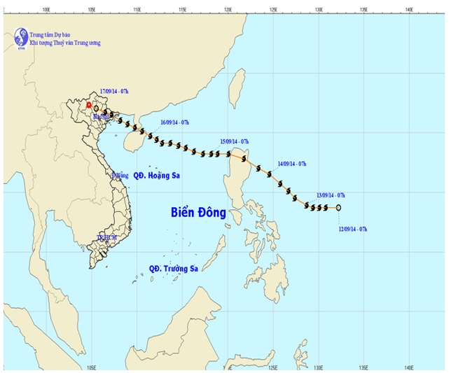
The after typhoon surges in typhoon Kalmaegi-14 hit on Quang Ninh (see Figure 3 ) occurred during the low tide phase and did not cause flooding at that time. However, 6 hours later, the circulation due to the typhoon combined with the South-West monsoon caused the seawater level rises of about 1.0m, in 14 hours at Hon Dau station (see Figure 4 a) and of about 0.7m, in 5 hours at Hon Ngu station (see Figure 4 b). This typhoon surges combined with high tides and high waves had caused severe flooding in the coastal area of Do Son-Hai Phong as shown in Figure 5 .
Figure 4 . Observed seawater level, predicted tide and surge due to typhoon Kalmaegi-14: (a)-at Hon Dau station and (b)-at Hon Ngu station

Simulating after-typhoon surges caused by typhoon Kalmeagi-14 using integrated model SuWAT
From the analytical results of the typhoon Kalmeagi-14 landed in Quang Ninh, initially revealed the cause of significant seawater level rises after typhoon landfall. In which the SuWAT model is applied to the simulation calculation under two alternatives for the wind and pressure fields (two calculating scenarios). Scenario N o 1 uses wind and pressure fields, which is calculated from the analytic typhoon model (Fujita model) according to typhoon parameters (including the typhoon center, the lowest air pressure at the center and the maximum wind speed). Scenario N o 2, the wind and pressure fields are got from the WRF meteorological field prediction model, currently running at the Center Hydrometeorology forecast center for official forecast.
Figure 5 . (a)- High waves had caused severe flooding in Do Son-Hai Phong and (b)-High typhoon surge distribution (forecast 12 hours prior to typhoon landing) in the typhoon Kalmaegi-14 hit on Quang Ninh (source Dau tu paper-http://www.baodautu.vn 20 )
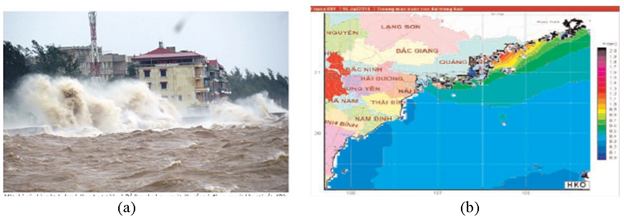
Figure 6 . Wind fields during the time before and after typhoon Kalmeagi-14 landed on: (a) 19:00 16/9; (b) 01:00 17/9; (c) 07:00 17/9; (d) 13:00 17/9
| Typhoon name | Landfall location | Landfall time | Max seawater level rises [m] | Occurred moment [hour] | Lasting Time [hour] | Occurred location |
| CHARLOTTE-62 | Thanh Hoa | 17h 22/09/1962 | 0.77 | 4 | 4 | Hon Ngu |
| N0 03-62 | Thua Thien Hue | 09h 27/09/1962 | 0.61 | 8 | 8 | Hon Ngu |
| FAYE-63 | Nam Dinh | 05h 09/09/1963 | 0.85 | 4 | 6 | Hon Dau |
| WINNIE-64 | Quang Ninh | 04h 03/07/1964 | 1.11 | 4 | 13 | Hon Dau |
| 0.71 | 8 | 4 | Hon Ngu | |||
| CLARA -64 | Ha Tinh | 07h 08/10/1964 | 0.66 | 7 | 6 | Hon Dau |
| NADINE-65 | Nghe An | 16h 18/08/1965 | 1.12 | 7 | 11 | Hon Ngu |
| HARRIET-71 | Ninh Binh | 22h 07/07/1971 | 0.61 | 12 | 4 | Hon Ngu |
| VERA-83 | Quang Ninh | 06h 18/07/1983 | 1.16 | 4 | 10 | Hon Dau |
| N0 01-83 | Thanh Hoa | 23h 03/10/1983 | 0.69 | 6 | 7 | Hon Ngu |
| WAYNE-86 | Thai Binh | 01h 06/09/1986 | 0.63 | 8 | 4 | Hon Dau |
| ANGELA-89 | Quang Binh | 17h 10/10/1989 | 0.62 | 11 | 7 | Hon Dau |
| ZEKE-91 | Quang Ninh | 03h 14/07/1991 | 1.03 | 4 | 9 | Hon Dau |
| 0.61 | 7 | 5 | Hon Ngu | |||
| FRANKIE-96 | Nam Dinh | 04h 24/07/1996 | 0.79 | 5 | 6 | Hon Ngu |
| WILLIE-96 | Nghe An | 00h 22/09/1996 | 0.75 | 20 | 3 | Hon Ngu |
| KAEMI-00 | Da Nang | 15h 22/08/2000 | 1.58 | 5 | 7 | Hon Ngu |
| KALMAEGI-14 | Quang Ninh | 22h 16/09/2014 | 0.98 | 4 | 14 | Hon Dau |
| 0.64 | 7 | 5 | Hon Ngu |
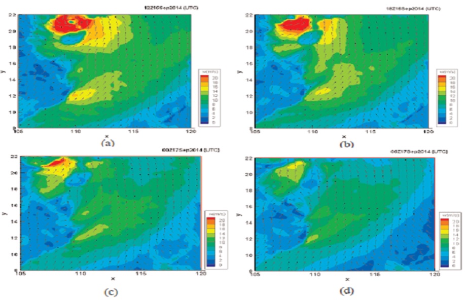
During the time when typhoon Kalmeagi-14 landed in the coast of Quang Ninh on 16/9/2014, the wind fields predicted by the WRF model show that after the typhoon had dissolved, the strong South-West wind existed as shown in Figure 6 .
In Figure 7 , the wind speed, air pressure comparison between the observation, calculation by the Fujita model and prediction by the WRF model and the monitoring data at the Hon Dau meteorological station. The results show that there is quite a similarity between WRF model calculation and monitoring data. The analytical Fujita model, gives a very high error with higher pressure, the time when the wind speed appears earlier and higher is because it is impossible to describe the wind field under the condition of South-West monsoon acting. Due to the unreal wind and air pressure fields calculated by Fijita model in Figure 8 , the calculated sea water levels also had a bad agreed with the observed data.
Figure 7 . Measured and predicted wind speeds (a) and pressure (b) at Hon Dau station in the typhoon Kalmaegi-14 hit on Quang Ninh

Figure 8 . Highest typhoon surge distribution caused by Kalmeagi-14. (a) Wind and pressure fields calculated by Fujita model and (b) by the WRF model.

Quang Ninh coastal area; in Hai Phong coastal area the highest seawater level rises was only 0.6m. Meanwhile, the scenario N o 2 (using WRF wind fields), the distribution of significant seawater level rises across a wide area from Quang Ninh to Nghe An.
Some numerical experiments with the ROM and JMA models are also carried out. The calculated results show that the numerical models all with the wind and air pressure fields described by Fujita model are impossible to simulate the typhoon surges occurred after the landfall time as the case of the typhoon Kalmeagi-14. With the wind fields of WRF, the models all can produce the better results in comparison with the observed data, as shown in Figure 9 . At both tide gauges stations, Hon Dau and Hon Ngu, the SuWAT model calculated with WRF wind fields always have the better results in comparison to the observed data, while the SuWAT model can produce the unreal seawater down as shown in Figure 9 b.
Propagation of typhoon surges along the coastal zone
Figure 9 . Calculated seawater levels during the typhoon Kalmeagi-14 by the different numerical models the wind and pressure fields from Fujita and WRF models: (a)-Hon Dau station and (b)-Hon Ngu station.

In order to find out different reasons to cause the after-typhoon seawater level rises one more numerical scenario (No3) is carried out. In 1985 a strong typhoon occurred in the East-Vietnam sea and landed on Quang Binh coast, called Cecil-85. This typhoon caused severe surges along the long coast from Quang Binh to Nghe An. The maximum observed typhoon surge of 2.1m occurred at the latitude of 16.9oN, furthermore, at Hon Dau station the max surge was also greater than 0.8m, 1 .
The scenario No3 calculated the seawater level rises caused by the typhoon Cecil-85, using the wind and air pressure fields by Fujita model until the typhoon landed on the coast, from the landfall time to the end of calculation (in 15 hour) the wind fields of zero m/s and constant air pressure fields were applied. In other words, the status of seawater level rises and currents at the typhoon landfall time were considered as the initial conditions in order to investigate the propagation of surges in the sea area without any influence of wind or air pressure disturbance.
In the Figure 10 , the variation of seawater level rises along the coast from latitude of 16 o N to 21 o N from the landfall time to 13 hour later are presented. It is shown that at the typhoon landfall time, the highest surge occurred around the latitude of 17 o N, then it moved northwards, after 2 hours its peak appeared at about 18.6 o N and after 4 hours at 20.5 o N. Therefore, it is considered the typhoon surges as a long wave and propagates northwards along the coastal zone and reaches the head of the gulf of Tonkin after about 5.5 hours. It propagation is estimated by the black line in Figure 10 . The high seawater level rises at 21.5 o N after 8-9 hours is explained due to the reflection of the surges to the head of the gulf. It is noted that during propagation, the height of surge is reduced significantly, however depending on the depth and shoreline configuration it may be increase slightly.
Figure 10 . Propagation of typhoon surges along the coast after the typhoon landfall time.

CONCLUSIONS
High typhoon surges are possible to appear after the typhoon landfall time and exist for a long time, several to ten hours or more. This phenomenon appears rather frequently in the north coastal zone of Vietnam. On the basis of the historical typhoon data from 1960 to 2017 and the hourly measured seawater level at three tide gauge stations, the statistical results show that among 101 typhoons caused significant seawater level rises, there were 16 typhoons (about 16%) caused significant seawater level rises after typhoon landfall time. Therefore, warnings, forecasts and related issues need to pay attention even after the typhoon has landed.
On the basis of calculated results by SuWAT model and others it is revealed that in some cases the significant seawater level rises are due to the combination of wind circulation after typhoon landfall and monsoon. In order to predict well these cases it is recommended to use WRF wind and air pressure fields for the numerical calculation.
High seawater level rises after typhoon landfall also appears due to the propagation of surges as a long wave along the coastal zone. AS the preliminary estimation, a typhoon landed on the coast of the Middle of Vietnam may be cause a significantly seawater level rises in Hai Phong-Quang Ninh coastal zone in 5-6 hour after its landfall time.
LIST OF ABBREVIATION
JMA: Japan Meteorological Agency
ROM: Reduced-Order Model
SuWAT:Surge, Wave and Tide
WRF: Weather Research and Forecasting
AUTHOR CONTRIBUTIONS
All authors contributed equally to this work. All authors have read and agreed to the published version of the manuscript.
CONFLICT OF INTEREST
We declare that there is no conflict of whatsoever involved in publishing this research.
References
- Manh D.V.. Typhoon surges in the coastal zones of Vietnam. Monographs on Marine science and Technology, Science and Technology House. 2018;:. Google Scholar
- Chien D.D.. Some calculation results of tides, waves and typhoon surge due to SuWAT model. Proceedings of the national scientific conference on meteorology, hydrology, environment and climate change. 2014;:. Google Scholar
- Dao L.T.. Calculate tides, typhoon surges and their interactions with the Hydrodynamic numerical model. Topics of General Department, General Department of Meteorology. 1999;:. Google Scholar
- Hien N.X.. Study on typhoon surges in consideration of wave setup and its application. Dortoral thesis on physical oceanography, Vietnam. 2013;:. Google Scholar
- Lien N.T.V.. A numerical model for tide and typhoon surges in the East-Vietnam sea. Doctoral Thesis on Fluid Mechanics, Hanoi, Vietnam. 1997;:. Google Scholar
- Manh D.V.. Study on energy in water volume during the typhoon acting in the Gulf of Tonkin. Proceedings of the 5th national conference on Mechanics. ;4:. Google Scholar
- Manh D.V.. Model of simultaneous calculation of waves, typhoon surges and tides in the Northern gulf. Collection of National mechanical engineering conferences. 2009;:. Google Scholar
- Manh D.V.. Developing and improving numerical models for wave, typhoon surge and tide in Vietnam sea areas. Vietnam Academy of Science and Technology project. 2012;:. Google Scholar
- Ninh P.V.. Typhoon surge and monsoon winds. State-level marine research program KHCN-06 (1996-2000), East Sea, Meteorology hydrology, marine dynamics. Hanoi National University Press, Vietnam. 2000;:. Google Scholar
- Quynh D.N.. Technology for typhoon surge prediction in the coastal zones of Vietnam. The national project KT.03.06. 1996;:. Google Scholar
- Quynh D.N.. Application of technology procedure for typhoon surge prediction. The VAST project, Vietnam. 2001;:. Google Scholar
- Thuy V.T.T.. Storm surge modelling for Vietnam's Coast. TU Delft, The Netherlands. 2003;:. Google Scholar
- Sao N.T.. Calculating and predicting typhoon surges by using the meteorological model RAMS. Thematic report in the national project KC 09-04. 2001;:. Google Scholar
- Kim S.. Typhoon surges along the Tottori coasts following a typhoon. Ocean Engineering. 2014;91:133-145. Google Scholar
- Fujita T.. Pressure distribution within typhoons. Geophysical Magazine. 1952;23:437-451. Google Scholar
- Moi N.V.. Tide analysis by the least square method and its applicationsfor Vietnam sea area. Master thesis on fluid mechanics. Institude of Mechanics, Vietnam. 2002;:. Google Scholar
- Thuc P.T.. Typical typhoon surge due to the Northern coastal region. Collection of National mechanical engineering conferences. 2018;(21):762-772. Google Scholar
- . . ;:. Google Scholar
- . . ;:. Google Scholar
- . . ;:. Google Scholar