Open Access
 Abstract
Because many existing structures, such as administrative, heritage, or university buildings that were constructed several decades prior, do not have sufficient paperwork and plans, the digital restoration of records for future management is currently facing a great deal of difficulty. Once the Building Information Modeling (BIM) information model is constructed, establish a connection and transmit the database via the Geographic Information Systems (GIS) environment to enhance the efficiency of project design, construction, and operation management. This will also serve as a database for future Smart city initiatives. Additionally, the traditional techniques of assessing existing conditions are labor-intensive and time-consuming, and the drawings of the as-built state are not necessarily correct. This study was carried out to enable the restoration of three-dimensional models of buildings by utilizing cutting-edge technologies such as BIM-GIS. The purpose of this study was to solve the problem that had been identified for Asset Management in Old Building. Building B6, which houses the Faculty of Civil Engineering at Ho Chi Minh City University of Technology (HCMUT), Vietnam National University, Ho Chi Minh City, serves as the case study for this kind of investigation. The first thing that has to be done is to use Scan-to-BIM to create a digital model of Building B6, and then the next step is to upload the BIM model to the GIS platform and check the conflict between each model thereafter. In conclusion, the study comes to a close by presenting its findings and providing an outline of potential future research topics.
Introduction
With the rapid and sustainable development trend in the construction sector, new tools and techniques such as simulation software for Building Information Modelling (BIM) and Geographic Information System (GIS) are greatly influencing the industry. Furthermore, there is an increasing demand for data products from existing structures, monuments, and museums. In the restoration and preservation of buildings, two important technologies that are commonly used are BIM and GIS. These technologies accurately document and analyze the current status of buildings, which is an essential step in the restoration process.
The Scan-to-BIM process involves 3D laser scanning to create a digital model of the building, gathering detailed information about its structure, geometry, and materials. Professionals can use Scan-to-BIM to create detailed virtual representations of buildings, which can be used to plan and perform restoration work. On the other hand, GIS technology involves mapping and analysis tools to organize, manage, and visualize geographic data. GIS can collect and analyze information about the building site, such as topography, geology, and vegetation. By integrating this information with the 3D model generated by Scan-to-BIM, restoration professionals can gain a better understanding of site conditions and how they may impact restoration work.
Together, Scan-to-BIM and GIS provide a comprehensive view of the building and its surroundings, which can help professionals to identify areas of damage or deterioration, plan restoration work, and monitor progress. Firstly, professionals can use Scan-to-BIM to identify areas of the building that require attention. By integrating this information with GIS data, they can also identify potential causes of damage, such as water infiltration or seismic activity. Secondly, using the digital model generated by Scan-to-BIM, professionals can plan restoration work in detail, determine the best methods for repair and restoration, as well as estimate the cost and timeline for the work. Lastly, professionals can monitor the progress of the restoration work and make adjustments as needed by comparing the digital model generated by Scan-to-BIM to the actual state of the building over time.
The application of Scan-to-BIM and GIS technologies in the restoration and preservation of buildings is an effective way to document and analyze the current status of the building. These technologies provide a detailed and comprehensive view of the building and its surroundings, which can help professionals to plan and execute restoration work more effectively. By utilizing BIM and GIS, restoration professionals can save time and costs, while ensuring the preservation of historic buildings for future generations.
LITERATURE REVIEW
The restoration and preservation of historic buildings require accurate documentation and analysis of their current status. Two technologies that have gained significant attention in recent years are Scan-to-BIM and GIS. This literature review provides an overview of the current research and practical applications of these technologies in the restoration and preservation of buildings.
The practical application of Scan-to-BIM and GIS has brought about numerous benefits, and as a result, many related studies have been conducted. For instance, S. Amirebrahimi et al. demonstrated that combining ground 3D laser scanning equipment with aerial data collection from unmanned aerial vehicles (UAVs) ensured the collection of point cloud data for all project information 1 . Additionally, the data obtained from these sources contains billions of data points, each with coordinate information (X, Y, and Z) and color parameters, making the current 3D laser scanning technology highly accurate. The data processing procedure used in the study has demonstrated the feasibility of combining data from different sources. In the future, more in-depth studies will be conducted to evaluate the accuracy of independently collected data and data collected from a variety of devices. Therefore, the use of 3D laser scanning in the construction industry is further encouraged. In the future, the use of 3D laser scanning technology for survey, design, and inspection projects, as well as the creation of BIM models for construction management, will become practical and effective. The benefits of BIM models in operations management are summarized as follows: they support the collection and integration of all building data in multi-model dimensions, offer excellent visualization, and provide synchronization 2 . Additionally, the study conducted by Kalantari et al. 3 on archaeological information modeling employed two approaches: reconstruction-oriented digital model representation and resource concentration for building maintenance. New sections were generated as building simulations. Both BIM systems conveyed the available details most effectively, from the lowest representation as blocks to the highest representation as geometrical details and related information, in terms of level of development (LOD). Furthermore, Zhu et al. 4 interviewed experts who had implemented BIM in three renovation projects and recommended that operational management information should be included in the BIM model as early as possible. The article also presented a list of necessary information for a renovation project, including structural specifications, space, construction site, MEP system, renovation and survey information, and document accuracy. In a study by I. M. Badwi et al. 5 , it was demonstrated that the application of geographic information system (GIS) in management has many benefits, such as increasing capacity, saving time, boosting productivity, and improving work efficiency. The analytical skills required for GIS applications are statistics and modeling. The primary objective of any analytical system in a geographic information system is to understand the relationship between spatial locations and geographic phenomena. Providing information in a timely, intuitive, and comprehensive manner is crucial to achieving this objective. GIS also provides important information to support sustainable development strategies.
Overall, the review highlights the importance of Scan-to-BIM and GIS technologies in the restoration and preservation of buildings. These technologies enable accurate and comprehensive documentation and analysis of building structures, which is crucial in planning and executing restoration work. Future research will likely focus on improving the accuracy and efficiency of these technologies, as well as exploring their potential for other applications in the construction industry.
Methods
The study methodology integrates on-site data gathering using Point Cloud Data, as well as the acquisition of background information from various sources, which is conducted off-site. Point Cloud Data is mostly utilized for quantitative purposes. It gathers data in the form of intricate figures and photos of study subjects, enabling precise analysis and processing of information using specialist software. Quantitative data plays a crucial role in the development of three-dimensional models and the execution of targeted geographic and dimensional analysis on research subjects. Gathering background information and data from external sources often involves qualitative methods, such as analyzing language, referring to documents such as-built drawings, past reports, and seeking expert opinions through interviews or conversations. Qualitative data plays a crucial role in offering contextual information, theoretical framework, and a more profound comprehension of the research population and surroundings.
Figure 1 illustrates the research framework for achieving the research objectives, which consists of three crucial stages. In stage 1, the study explores relevant documents, proposes a Scan-to-BIM process, and places the resulting BIM model on the GIS platform. In stage 2, this process is applied to a specific case study of the B6 building in the Faculty of Civil Engineering. Finally, the research team conducts a potential application evaluation to determine the effectiveness and usefulness of Scan-to-BIM and GIS technology in restoring and preserving buildings. A process assessment is also incorporated to identify the process's strengths, limitations, and areas for improvement. Through these steps, the study successfully demonstrates the potential of Scan-to-BIM and GIS technologies in accurately documenting and analyzing the current condition of buildings for restoration and conservation purposes.
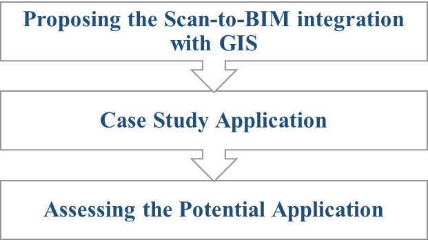
Figure 2 illustrates the research framework for achieving the research objectives, which consists of three crucial stages. In stage 1, the study explores relevant documents, proposes a Scan-to-BIM process, and places the resulting BIM model on the GIS platform. In stage 2, this process is applied to a specific case study of the B6 building in the Faculty of Civil Engineering. Finally, the research team conducts a potential application evaluation to determine the effectiveness and usefulness of Scan-to-BIM and GIS technology in restoring and preserving buildings. A process assessment is also incorporated to identify the process's strengths, limitations, and areas for improvement. Through these steps, the study successfully demonstrates the potential of Scan-to-BIM and GIS technologies in accurately documenting and analyzing the current condition of buildings for restoration and conservation purposes.
Based on the results of related studies and the research team's participation in similar projects, the study proposes a Scan-to-BIM process that aligns with the research requirements. With today's advanced 3D Laser Scanning technology, the scanner can collect millions of data points per second. Using this data, the true 3D model of the building can be completely reconstructed, which is extremely helpful for long-standing structures such as the B6 building at the Faculty of Civil Engineering.
Figure 2 illustrates the Scan-to-BIM process for building B6, which consists of two main steps:
- Field data collection: This involves obtaining geodetic coordinates of test points and building point cloud data.
- Information data collection: This step includes collecting essential building information, operation management processes, asset import/export processes, and asset management.
The whole-building 3D data capture technique, Terrestrial Laser Scanning (TLS), can rapidly and accurately gather information on even the most complex building components. The device's sensor and camera provide photogrammetry data, which is used for visual comparison with the point cloud model to facilitate data station pairing. The result is a precise 3D point cloud of the project to be surveyed, which is used to reconstruct the building's 3D model. This model then serves as the building's BIM model, which can be used for various purposes, such as storing and updating the current state of the project and integrating it into the building operation management process.
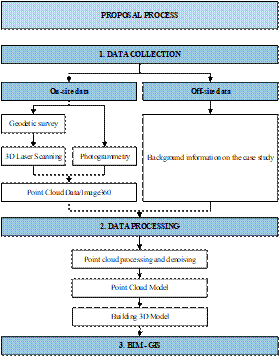
In terms of 3D Laser Scanning, empirical evidence suggests that the optimal period for collecting outside data is between 5:30 am and 5:30 pm, since this is when the light intensity is sufficient for the device to efficiently analyze and automatically link stations on the field software. The total inaccuracy in this case study was below 10 mm. The step-by-step process followed in field data collection includes preparation work, data collection sequence, handling challenges, and ensuring data accuracy and consistency. For the B6 building survey project, 112 computer stations were placed to capture all data of this project. The preliminary result for this step is the obtained rough point cloud model of the construction area, which includes a lot of unnecessary points of objects within the scanning radius of the device.
To facilitate the integration of BIM and GIS, the researcher utilized ArcGIS Pro software. This GIS program, developed by Esri, includes tools for creating professional maps, data visualization, and sophisticated data analysis. Esri has successfully collaborated with Autodesk Revit products to jointly create the integration of BIM and GIS, which has significantly increased efficiency 6 . Utilize Trimble Realwork software to do subsequent processing on the raw data obtained from the field. This involves filtering out noise points and restricting the tasks that require further processing. The gathered point cloud data may be regarded as a very precise 3D as-built data, which can be utilized to verify, retain, and reassess the present condition of the building site throughout that period.
Following the use of specialist point cloud processing software provided by the organization, the Autodesk Recap program is employed to facilitate the viewing, observation, verification, measurement, and partitioning of point cloud data into smaller clusters. This software aids engineers and technicians in efficiently and conveniently utilizing the data.
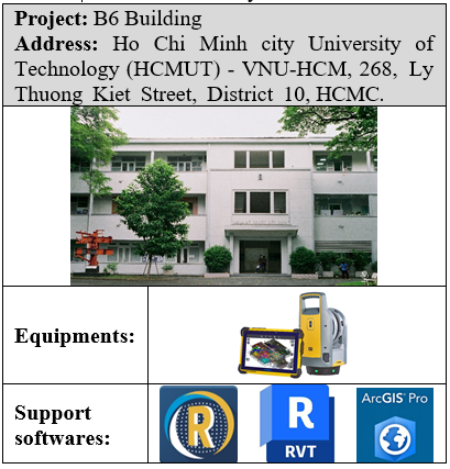
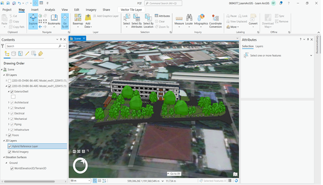
Figure 5 provides information on the case study, as well as the supporting equipment and software used in the study. Building B6, located on the campus of Ho Chi Minh City University of Technology (HCMUT) - VNU-HCM, is a part of the Faculty of Civil Engineering. The building has been in use for 65 years and has undergone several maintenance and repair works to meet user requirements. While its condition is still good, the current state of the building may differ somewhat from its original design.
Results and discussion
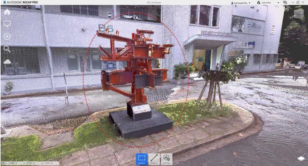
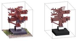
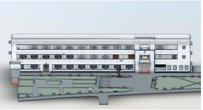
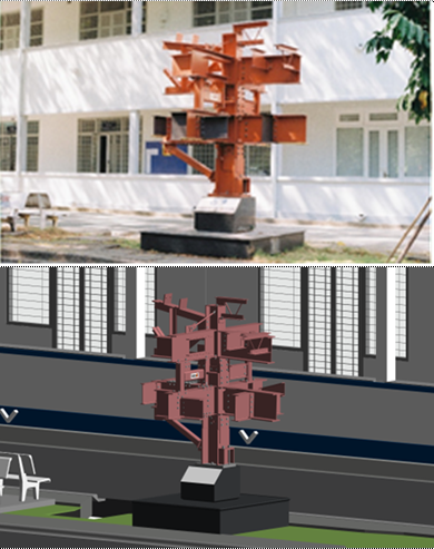
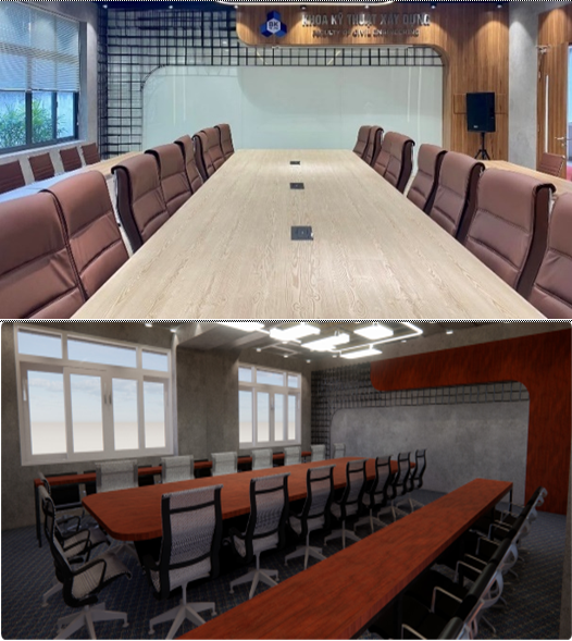
Using the Scan-to-BIM process, which involves two main steps: field data collection and data processing, on-site data is collected and processed. The study has successfully applied the process and reconstructed the overall 3D model of the B6 building. Figure 3 shows the general 3D model of building B6, while Figure 4 show the steel structure at the actual building B6 and after digitization.
The section on implementing the proposed process for a case study discusses in detail the two phases of the research process:
- Identifying information and data related to building B6, as well as the current state of the building's equipment.
- Applying the Scan-to-BIM process and putting the BIM model on the GIS platform for building B6 - Faculty of Engineering, which is shown in Figure 6 .
As a results, assessing the sustainability of buildings and their environmental impact becomes more accurate with the combined data from BIM and GIS. For existing buildings, this integration can aid in efficient maintenance and operations by providing comprehensive data about the building in relation to its environment.
The study successfully updated the entire 3D model of building B6 on the GIS platform, synchronized the information layers from the BIM model, and created property information of the model on the GIS platform. Figure 7 depicts the results after integrating BIM into the GIS platform.
BIM-GIS applications can optimize the process of storing building information, as illustrasted in Figure 8 . Currently, the building's state is stored in 2D drawings, which do not reflect changes made during editing and renovation. However, by incorporating BIM-GIS in management work, information storage can be optimized, and the 3D model can be made more intuitive and easily converted into 2D drawings if needed. Incorporating BIM into the management process offers a significant advantage of quick updates during renovations. With a BIM model, there is no need to manually update related 2D drawings when there are renovation or repair works on the existing conditions. Instead, everything will be automatically and accurately updated, and we only need to ensure the quality of the 3D model. Figure 9 demonstrates how the 3D model is quickly updated when there are architectural changes or edits.
By combining the detailed interior information from BIM with the broad geographical data from GIS, decision-makers can make more informed choices about construction, renovation, and maintenance. The integration allows for effective management of building assets, including utilities and infrastructure, by providing a complete view of how these interact with the surrounding environment.
Conclusions
The research has successfully implemented the complete Scan-to-BIM process and partially comprehended the current state of building operation management based on the collected data (case study). Creating 3D models for existing buildings will optimize the administration and operation of buildings, enabling the management unit to monitor, update, and manage their structures more efficiently. By incorporating BIM in building management, the research provides a significant contribution to constructing more comprehensive and efficient procedures that will increase unit productivity and lower unit costs for building managers. The exported processes will serve as the basis for relevant future research, which has significant growth potential in the context of digital transformation. In the future, updating the BIM model to the GIS platform will provide many advantages in terms of management, which are essential management skills when constructing smart city projects. With the complementary benefits and drawbacks of BIM and GIS, the management process can be optimized throughout the building's life cycle. Understanding and proposing the process of synchronizing management duties on the web application platform will enable users and operation management units to manage and access voluminous amounts of data quickly and easily .
Integrating Building Information Modeling (BIM) with Geographic Information Systems (GIS) in real-time is a cutting-edge approach in the field of architecture, engineering, and construction. The integration enables real-time analysis and simulation of various scenarios, such as emergency response, urban development, and environmental impact assessments. This synergy of BIM and GIS in real-time promises to revolutionize the way buildings and infrastructure are planned, designed, constructed, and managed, leading to smarter, more sustainable, and resilient urban environments.
Competing Interests
The authors declare that they have no conflicts of interest.
Authors' Contributions
Thu Anh Nguyen and Thai Quoc Phan participated in coming up with article ideas, collecting data and writing the manuscript. Hai Phu Huynh built the model and tested the conflict. Phuoc Quy Dao contributed to data interpretation and proofreading of the article.
ABBREVIATIONS
BIM: Building Information Modeling
TLS: Terrestrial Laser Scanning
GIS: Geographic Information Systems
References
- Amirebrahimi S., Rajabifard A., Mendis P., Ngo T.. A BIM-GIS integration method in support of the assessment and 3D visualisation of flood damage to a building. Journal of Spatial Science. 2016;61(2):317-50. Google Scholar
- Kumar S., Bansal V.K.. GIS-based locational evaluation of infrastructure facilities in hilly regions: a case study of an institute campus. International Journal of Construction Management. 2019;21(11):1165-84. Google Scholar
- Kalantari M., Olsen M.J.. Nexus of BIM and GIS: integrating building and geospatial data. Journal of Spatial Science. 2020;65(2):191-2. Google Scholar
- Zhu J., Tan Y., Wang X., Wu P.. BIM/GIS integration for web GIS-based bridge management. Annals of GIS. 2020;27(1):99-109. Google Scholar
- Badwi I.M., Ellaithy H.M., Youssef H.E.. 3D-GIS Parametric Modelling for Virtual Urban Simulation Using CityEngine. Annals of GIS. 2022;28(3):325-41. Google Scholar
- Wang X., Xie M.. Integration of 3DGIS and BIM and its application in visual detection of concealed facilities. Geo-spatial Information Science. ;2022:1-10. Google Scholar